The Newest Rabbit Island Google Photo: Notes on Satellites, Islands, and Ethics
Rob Gorski
March 2014
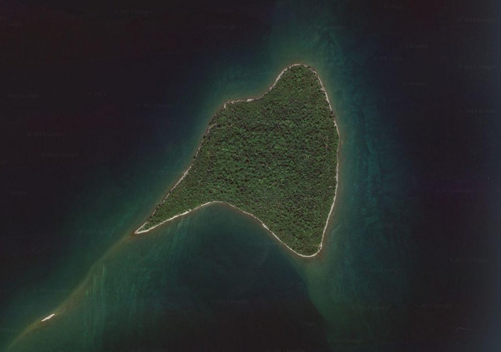
Recently Google uploaded a new satellite image of Rabbit Island. It is an amazing shot. From a camera fixed in orbit 423 miles above our planet you are able to discern features that, until recently, you needed a wetsuit and goggles to see. In amazing detail, you can see, 25 feet under Lake Superior’s surface, the island’s stone reefs. Off the northern tip you can see Moon Break (first surfed in July of 2013 by Ben Moon and Rob Gorski), a right break that forms when north winds blow from between Louis Point and Bete Gris farther up the Keweenaw Peninsula. Off the southeast point, you can see a shallow underwater sandstone ledge that creates breaking waves given an east or northeast blow greater than 20 knots. Those waves build over several hundred miles of fetch from Canada, crash over Rabbit Island, and then flatten again when the depth drops to a deeper blue. With our 13-foot Boston Whaler we’ve surfed some of those waves, too. If you look more closely in the shallows, you can see shoals that native Lake Superior Redfin Trout use for spawning. These shoals are made of layers of head-sized rocks, the result of more than ten-thousand freeze-thaw cycles splitting apart Jacobsville sandstone as it rises to form the island. According to fishermen we’ve bumped into in Calumet, on clear, calm days late in the year you can see trout spawning in these shallows, and when scared by a boat, scurrying between stones, hiding in the many nooks.
Up out of the water you can see the white cobble shoreline, and inside it a dense, green forest canopy. If you look more closely, you can also see individual mature trees, including several we’ve climbed. Off of the southwest point, you can see a dead and weathered deciduous tree that the island’s eagles frequently perch in. On the southern shore you can see a large white pine that toppled in 2012, and which, though partially submerged, has survived two seasons of ice and waves. We call it Big Leanie. On the northwestern shore, you can see the new shelter we began building in 2013—and you can see the roof on it, which we finished on August 10th. A quarter mile south, there’s main camp. The Rabbit Island School camped in the pines there from August 11th through the 17th, but none of their tents are in the satellite image. Four miles to the west, in Rabbit Bay, you can see the small harbor at the mouth of Lahiti Creek where Sisu, our Montauk 17, and our 13-foot Sport, rest on the southern dock. We pulled the boats out of the water on September 15th. By then, leaves were turning yellow, yet there’s no hint of yellow in the image. Taking this into account we estimate that Google shot this photo between August 18th and September 13th, 2013.
All told it is fascinating to consider how this small remote wilderness has now been archived. It is indeed an interesting time to be an environmentalist, and also an artist. Possibilities are certainly changing.
Scrolling around it is interesting to study this image of an ecosystem viewed in its geographic whole and reflect on the overarching idea that everything rising here above lake level will remain, so long as American contract law is valid, unimpeded forever. The island is 91 acres, of course—a mere speck on the scale of a region, state, country or continent—yet in the context of our culture this land and this image represent ideas that we believe are broadly relevant: intentional non-development, the assignment of value to intact watersheds, incorporation of non-financial environmental costs on balance sheets, restraint, community involvement in conservation, wise legislation, honest scientific inquiry, creative expression, the celebration of the natural rules of the game, rational reclamation, etc. The very fact that such satellite imagery of our planet exists changes the ethical fundamentals that every generation going forward must apply to land use.
Giving a voice to these ideas within our culture is one of the goals of the Rabbit Island project. Encouraging others to pursue similar projects is another. Contextualizing land to creative energy in plain terms is a third. Accordingly, it is logical to wonder whether the concept of this image—of this watershed, of those uncut trees—can ever be recreated on a larger, organized scale, and projected upon land where ecosystem integrity had previously been lost to subdivision. (A related essay exploring this can be found here.) We believe that such ideas must necessarily become part of our culture. As the ability of society to reasonably organize itself sustainably continues to progress we believe that wilderness, like art, will continually be seen as evidence of a civilized people, and, as a corollary, that a civilized people will become capable of creating the conditions necessary for sensible organization of environments on a larger scale than the individual. Wilderness, where it exists, after all, exemplifies civilization in our modern world.
As the snow accumulates on Rabbit Island and the ice on the shore thickens, we’re preparing for our 2014 Artists-in-Residence. Others are working on a handful of independent projects, continuing various scientific experiments, readying the second annual Rabbit Island School, and seeking the IRS accreditation of the 501(c)(3) Rabbit Island Foundation, a professionally-managed, crowdsourced, conservation fund. Still others are reporting last year’s artist activity, and—we’re crossing our fingers here—planning a fishing derby in late July. Summer’s coming, and it’s exciting as ever.
